


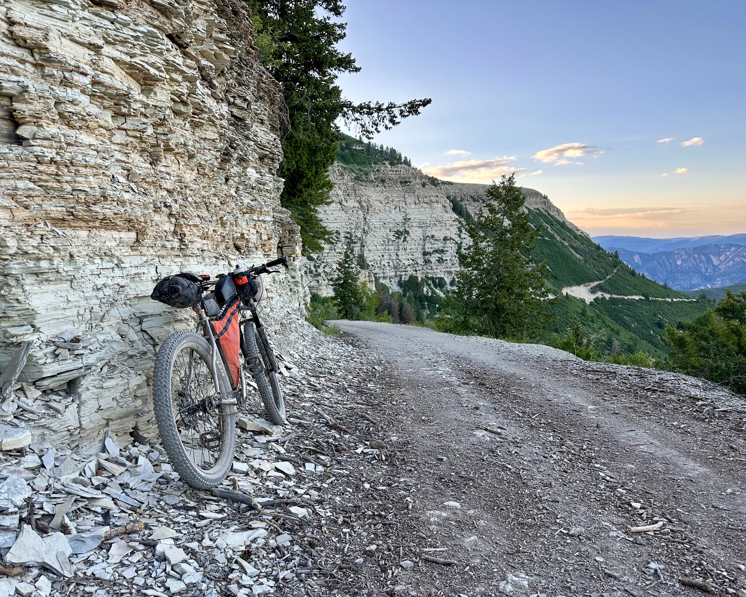
The Rolling Horse explores the varied landscapes of northwestern Colorado’s Grand Hogback, a 90-mile-long spine of deeply contested ground dividing the Southern Rockies from the Colorado Plateau. The route re-links lands once stewarded by the Nuche (Ute people); specifically, those who hunted amongst the high places we call the Elks, Raggeds, Flat Tops and Roan; and gathered along the banks of the White River.
Route Stats
Region: Central & Northwest Colorado
Season: Early July through Early October (depending on snowfall/melt)
Distance: ~465 miles
Elevation Gain: ~60,000 ft
Ride Duration: 9-14 days
Recommended Tire Size: > 2.3"
Physical Difficulty: 8/10
18% paved
4% smooth gravel
20% rough gravel
43% 4X4 road & two-track
15% singletrack
HIGHLIGHTS
Explores the region’s rich natural and human history
links the wild wonders of the Roan Plateau, Flat Top, Elk, and Ragged Mountains as a singular connected landscape
follows many longstanding backcountry roads that approximate the original migratory, hunting, and trade routes of the Ute ancestors
passes through Carbondale, Aspen, Crested Butte, Rifle, Meeker, and Glenwood Springs, each of which have active historical societies and museums
visits many historic structures from the region’s early mining and agricultural era including: Crystal Townsite (Crystal), Crystal Mill Powerhouse (Crystal), Marble Millsite Park (Marble), Redstone Coke Ovens and Coal Basin Mining Memorial (Redstone), Thompson House, Jailhouse, and Cabin (Carbondale), Emma Store and Schoolhouse (Emma)
remembers the battle at Milk Creek; a poignant reminder of Manifest Destiny’s crushing injustice, and the Ute people’s stand of sovereignty over their ancestral homeland
passes the Stormking 14 Memorial honoring fourteen young firefighters trapped and killed by a wildfire on July 6, 1994 while protecting the community of Glenwood Springs; a tragedy that forever changed the way wildland fires are fought
traverses a portion of the Roan Plateau home to herds of wild horses descended from those once belonging to the Utes
climbs McClure Pass using the original wagon route
passes the Cayton Guard Station, one of the earliest Forest Service ranger stations in the country and the region’s longest standing testament to land conservation
overlooks thousands of acres of permanently conserved agricultural and wildland (private land protected by conservation easements) in both the Roaring Fork and Colorado River valleys
Connects several iconic backcountry ‘adventure’ rides
high-points the spectacular Crown Road south of Carbondale, and the full length of the Hay Park trail along the east flank of Mt. Sopris
traverses the entire Arbaney-Kittle backcountry epic (in what all but the most adventurous would say is the WRONG direction! ;)
overlooks several Elk Range 14ers while dropping into Aspen on the Sunnyside trail
follows the iconic Grand Traverse MTB race route from Aspen, up and over Richmond Ridge, Taylor Pass, and the route’s high point at Star Pass, culminating with an extra credit passage of the spectacular Deer Creek trail into Crested Butte
climbs the Alpe de Slate to Paradise Divide before descending Schofield Pass to the chunkiest gnar on the route, past the bowel-shaking Devil’s Punchbowl, followed by a quick glimpse of the historic Crystal Mill, and a proper feast in the tiny town of Marble, CO (make sure to catch Slow Groovin BBQ during business hours).
rambles the rough and tumble Raggeds trail; perhaps the most deceptively difficult, and breathtakingly scenic, trail on the route
traverses the Spruce Mountain ridgeline; amongst the most epic places on the planet to witness a fall foliage sunset over one of the largest living organisms on earth - the Kebler Pass Aspen Grove. The soul-crushing hike-a-bike to get there is worth every step.
climbs the 4,000’ JQS Road out of Rifle, Colorado and rambles along the rim of the Roan Plateau – perhaps the route’s most sublime section
enjoys many miles of zoomy gravel along the bucolic east flank of the Grand Hogback
follows remnants of ancient routes over Blair Mountain and the Flat Top range.
screams down the 5000’ descent of the Transfer Trail into Glenwood Springs (save some brake pads for this!)
absorbs huge views of Glenwood Canyon from the Boy Scout and Forest Hollow trails


ABOUT THE ROUTE
The Rolling Horse explores the varied landscapes of northwestern Colorado’s Grand Hogback, a 90-mile-long spine of deeply contested ground dividing the Southern Rockies from the Colorado Plateau. The route re-links lands once stewarded by the Nuche (Ute people); specifically, those who hunted amongst the high places we call the Elks, Raggeds, Flat Tops and Roan; and gathered along the banks of the White River.
The route was designed to highlight the region’s rich natural and human history. Much of it utilizes backcountry roads that approximate the original migratory and trade routes of the Ute ancestors. Other portions acknowledge the region’s more recent ranching and mining history. Yet others appreciate the region’s long-standing commitment to land conservation.
From recreational meccas like Aspen and Crested Butte, to the working lands of Rifle and Meeker, the route traverses a great diversity of people, places, and land use ideologies. Yet one important people, the first to live in this place, remain largely absent from its midst. With the passage of many generations since their violent expulsion from northwestern Colorado, the descendants of the White River Utes continue to face physical separation from the land their ancestors once roamed freely. Furthering this disconnection is that the land is now deeply divided by highways, fences, and laws that make it difficult (often impossible) to traverse from one place to another. Despite these barriers, much of the land remains open to the public; if one knows where, and how, to go.
The Rolling Horse Route is a suggested ‘where’ and ‘how’ for reconnecting – as one whole human experience – the landscape it traverses. It is not the only where and how. There are other ways to connect these places. Some are quicker and easier. The Rolling Horse prioritizes history and meaning over speed and ease. The route often takes the more difficult path to the higher ground, clearer view, and deeper memory.
There is a reason the route starts in Carbondale, Colorado. In 2014, a Town of Carbondale park was renamed from Bull Pasture Park to Nuche Park. The gesture was meant to recognize those displaced from the Roaring Fork Valley when white settlers arrived. Members of the ranching family who donated the small park to the town, were among the first to sign the petition. It read in part:
“We are proud of our ranching heritage but would like to take our history back another 9,000 years by acknowledging the indigenous people who came before. The park would be Nuche-Mu-Gu-Avatum-Ada’he, Nuche for ‘the people’s place of the heart,’ a name given to the valley by the Nuche elders Roland McCook and Clifford Duncan. We would call the park Nuche Park.”
Nuche Park lies along the banks of the Crystal River on the southern edge of town. The bosom of a mountain known as Sopris to some, the ‘Mother’ to others, fills the southern sky. Eagles nest nearby. It is a fine place to start a journey.
——————————
Let there be no confusion. This is a mountain bike ride, NOT a gravel bike ride. At ~465 miles, with an elevation gain approaching 60,000 feet, and many miles spent well above 10,000 feet of altitude, this route is very difficult; perhaps just slightly easier than the storied Colorado Trail. Though the route contains many miles of smooth(ish) gravel and dirt, a mountain bike with front suspension, and a minimum tire size of 2.3”, is highly recommended. There are several steep, and lengthy, hike-a-bikes – each to worthy rewards. Much of the singletrack (there are ~70 miles of it) is quite steep and rough. Much of the route’s ~200 miles of double-track is even steeper and rougher. High-elevation snowpack is the main limiting factor dictating the route’s riding season. Typically, most of the route is snow-free by mid-July and may remain passable until mid-October. The ‘best’ times to ride the route are July (maximizes natural water sources and wildflower viewing) and late September to early October (fall foliage season).
Food resupply is plentiful with seven sizeable towns, and several other food possibilities directly on (or a few miles off) the route. Camping options are abundant throughout the public lands the route traverses. There are two extended sections of private land on the western half of the route where camping is not allowed or extremely limited. Those are noted in the logistics section and GPS track with alternatives listed. Water availability ranges from plentiful and clear on the eastern half of the route to quite limited and dirty on the western half. A few sections require significant water carries, even along the eastern half of the route where it traverses extended sections of ridgeline with limited water sources. It may be necessary to carry as much as nine or ten liters of water capacity for a few sections during the driest and hottest parts of the summer. Proper water planning is critical to completing the route.
Those seeking a quicker, and/or somewhat less arduous experience may be interested to know that several (but not all) of the most difficult sections can be easily bypassed using semi-adjacent sections of paved/gravel trails and roads (noted in the Optional Bypasses section below).
The entire Rolling Horse Bikepacking Route Collection including the main route and all files associated with the optional bypasses can be found at this link: https://ridewithgps.com/collections/9965266


LOGISTICS
-
Please do not park at Carbondale’s Nuche Park (the starting point for the route). The parking lot is extremely small and overnight parking is not allowed. Vehicles may be parked and left for multiple days along most secondary surface streets within the Town of Carbondale (beginning ~0.5 mi North of Nuche Park).
-
Water availability ranges from plentiful and clear on the eastern half of the route to quite limited and dirty on the western half. A few sections require significant water carries, even along the eastern half of the route where it traverses extended sections of ridgeline with limited water sources. It may be necessary to carry as much as 9 or 10L of water capacity for a few sections during the driest and hottest parts of the summer. Proper water planning is critical to completing the route. The sections of the route where water access is most limited are as follows:
• Arbaney-Kittle Trail climb to Big Woody Creek stream crossing: These miles are EXTREMELY arduous (involving several lengthy uphill hike-a-bikes), possibly very hot, along a tight and technical ridgeline, with no water available for 16+ miles and 4500' of elevation gain. This section may be the crux of the entire route. Most riders should strongly consider taking the bypass (see ‘Optional Bypasses’ for an easier alternative).
• Aspen Mountain Summer Rd. to Taylor Lakes via Richmond Ridge: Be sure to leave Aspen with plenty of water. A big climb lies directly ahead with many miles of weather-exposed high alpine ridgeline to follow. Depending on recent snowmelt and rainfall, there may be no water available until the south side of Taylor Pass (~17 miles and ~6,000' of elevation gain from here). See ‘Optional Bypasses’ for an easier alternative.
• Crooked Creek (West of Spruce Mountain) to Rifle resupply: In late summer and early fall, drinkable water may be non-existent between Crooked Creek and Rifle (a distance of 42 miles with 2,300’ of challenging climbing in between). The safe plan is to fill up at Crooked Creek with enough water to reach Rifle.
• Rifle resupply to Meeker resupply: This is usually the longest (in terms of miles), driest, and hottest section between water stops. From late summer through fall, there may be no drinkable water available along this 63-mile stretch featuring 6800’ of climbing. The safe plan is to fill up in Rifle with enough water to reach Meeker, or see ‘Optional Bypasses’ for an easier alternative.
-
Food resupply is plentiful with seven sizeable towns and several other food resupply possibilities directly on, or a few miles off, the route. Many riders will never need to carry more than two days of food between most of the resupply points on the route. The longest distance between resupply points is between Meeker and Glenwood Springs, a distance of 107 miles with nearly 12,500 feet of climbing in between. Some riders may choose to carry 3-4 days of food for that section.
-
Most of the route traverses public land managed by the federal government (US Forest Service and Bureau of Land Management). Dispersed camping options are abundant throughout those sections of the route. Other sections utilize public roads bordered by private land. Do not trespass or camp on private land. The best way to know if you are on private, or public, land is to use an app such as OnX Maps (shows land ownership in reference to your location) in conjunction with signage on the ground. Please be aware there are two extended sections of private land on the western half of the route where camping is not allowed (or options are extremely limited). They are as follows:
• The area between the US Forest Service boundary near the Cayton Guard Station and JQS Road north of Rifle (roughly 30 miles) is entirely private land characterized by working cattle ranches mixed with oil and gas production. Do not plan to camp or sleep within this section of the route. These miles are relatively fast. Lodging is available in Rifle and dispersed camping is possible along JQS Road just north of town.
• The ~57 miles between Piceance Creek (north of Rifle), and the Milk Creek Memorial (northeast of Meeker) follow public roads bordered by private property (mostly). Trespassing is taken very seriously in this region. Do not camp or sleep on private land. These miles all pass quickly on good gravel and/or paved roads. There are camping and lodging options in Meeker if needed.
• It is safe to assume you should not camp along any of the paved sections of the route. The vast majority of those miles are bordered by private land.
-
There are no permits or fees required to ride the route.
-
• The three miles of the route that utilize Airport Road, directly east of Rifle, Colorado, has minimal shoulder and fast-moving traffic. Please ride with extreme caution.
• State Highway 13 (north of Rifle) is not suitable for cycling beyond where the route turns west onto the JQS Road turnoff. Shoulders are minimal to non-existent in places and vehicle traffic moves extremely fast and includes many large trucks. Should you choose the skip the JQS/Roan section, please see ‘Optional Bypasses’ for a safer alternative
• Riding your bike along I-70 between Canyon Creek and West Glenwood Springs is not a viable way to shortcut the route. It is neither legal nor compatible with life. You may be able to take a public bus (rfta.com), ride share service, or hitch a ride.
-
Those seeking a quicker, and somewhat less arduous experience may be interested to know that several (but not all) of the route’s most difficult sections may be easily bypassed using semi-adjacent sections of paved/gravel trails and roads. These are noted on the GPS track and below.
The entire Rolling Horse Bikepacking Route Collection including the main route and all files associated with the optional bypasses can be found at this link: https://ridewithgps.com/collections/9965266
• Arbaney-Kittle Bypass: MOST RIDERS SHOULD STRONGLY CONSIDER TAKING THIS BYPASS. The Arbaney-Kittle Trail is extremely arduous and time consuming, involves several lengthy uphill hike-a-bikes, is possibly very hot, along a tight and technical ridgeline, with no water available for 16+ miles and 4500' of elevation gain. This section may be the crux of the entire route. It may be optionally bypassed by taking the Rio Grande Trail (paved multi-use path) east, turning left onto Woody Creek Rd. (part paved, part gravel), and reconnecting with the route at the Tin Cup trail in Lenado. Download Arbaney-Kittle bypass GPX track here: https://ridewithgps.com/routes/47297433
• Richmond Ridge Bypass: This difficult section of the route up Aspen Mountain and across Richmond Ridge (~17 miles with ~6,000 feet of climbing) may be optionally bypassed on an easier route by climbing Castle Creek Rd. (paved) west of Aspen, then climbing Express Creek Rd. (steep, loose, 4x4 road) to reconnect with the route at the top of Taylor Pass. Express Creek Rd. is a difficult climb but not nearly as difficult as Aspen Mountain and Richmond Ridge. This bypass comes with the benefit of plenty of access to water along Castle Creek Rd. Download Richmond Ridge bypass GPX track here: https://ridewithgps.com/routes/47297514
• Deer Creek Bypass: If needed, the Deer Creek Trail can be optionally bypassed by descending Brush Creek Road, then taking any one of a number of roads or trails into Crested Butte, where one can easily reconnect with the route. Download Deer Creek bypass GPX track here: https://ridewithgps.com/routes/47297614
• Raggeds Bypass: The Raggeds Trail is one of the most spectacularly beautiful sections of the route. It is also deceptively difficult and time-consuming. This section can be bypassed very quickly by descending McClure Pass (Hwy 133) and reconnecting with the route at County Rd. 265. Download Raggeds Trail bypass GPX track here: https://ridewithgps.com/routes/47297703
• Spruce Mountain Bypass: The climb up and over Spruce Mountain involves 2.5 miles of extremely steep and loose uphill hike-a-bike. The view from the top is worth it! But, this section can be easily bypassed by simply continuing west on Buzzard Divide Rd. until it reconnects with the route at Crooked Creek. Download Spruce Mountain bypass GPX track here: https://ridewithgps.com/routes/47297790
• JQS/Roan Bypass: The nearly 4,000’ climb up JQS Road and traverse of the Roan Plateau can be optionally bypassed by turning right off of State Highway 13, onto State Highway 325 (towards Rifle Gap), then left onto County Road 252 to Meeker (mostly gravel). This saves many thousand feet of climbing and gets you to Meeker much quicker. Download JQS/Roan bypass GPX track here: https://ridewithgps.com/routes/47297866
• Carbondale to McClure Pass Bypass: In my opinion, this is the best way to split the RHR into two “halves”, particularly if you’d like to divide it evenly in terms of time-on-trail and if you’d like each of the two halves to maintain consistent character throughout. Highway 133 intersects the route in FOUR places in the vicinity of McClure Pass, so you can pick your poison as to where to hop on or off the main RHR. Please note that both the old McClure Pass wagon road and Raggeds trail sections of the RHR have more in common with the technically demanding S/E half of the route than they do the much less technical and much faster riding N/W half. This bypass is anywhere from 19 to 30 miles, all paved, depending on where you reconnect with the route. Leaving Carbondale, the first five miles of the bypass follow a paved multi-use path on the E side of Highway 133. From the end of the multi-use path, you’ll have to ride the paved road. There is not much of a shoulder until you get to the base of McClure Pass, but vehicle traffic is usually light and since there is no cell service reception in the Crystal canyon drivers have less to distract them. The climb and descent of McClure Pass do have a decent shoulder (both sides). Depending on where you reconnect with the main RHR, this bypass allows you to do a S/E loop that is anywhere between 176 and 228 miles long and/or a N/W loop that is between 299 and 329 miles in length. Download the Carbondale to McClure Pass bypass here: https://ridewithgps.com/routes/54501407
• Divide Creek to Carbondale Bypass: Though this looks like an even-split mileage wise, the S half of the RHR is much more difficult and considerably slower than the N half. If your goal is to split the RHR in half time-wise, use the Carbondale to McClure Pass bypass. Otherwise, this is a great option for splitting the route into two smaller sections. This 35.7 mile long bypass follows a mix of ~25.5 miles of quiet gravel roads with ~10 miles of scenic/rural paved roads on the Carbondale end. Using this bypass to start and finish in Carbondale enables you to do a S/E loop of the RHR that is 279 miles long and/or a 263 mile long N/W loop. Download the Divide Creek to Carbondale Bypass here: https://ridewithgps.com/routes/54501376
• Divide Creek to Glenwood Spring Bypass: Use this bypass if you want to to do all of the main Rolling Horse Route that lies north of I-70 (Roan and Flattops) as a loop, while keeping the route as short as possible. This 32.4 mile long bypass follows ~20.5 miles of mostly quiet gravel roads followed by ~9 miles of paved country roads and finishes with ~3 miles of paved bike path through Glenwood Springs. Utilizing this bypass to start and finish in Glenwood Springs enables you to blitz a fast moving 232.6 mile loop through the N/W portion of the RHR, and/or do a MUCH more arduous 298.7 miles long loop of the S/E part of the route. Download the Divide Creek to Glenwood Springs Bypass here: https://ridewithgps.com/routes/51942078


WHY ROLLING HORSE?
According to the record of those fossils so far discovered, the horse first appeared in North America about four million years ago. Its ability to migrate great distances over challenging terrain made it a very successful species and its range expanded – first to South America, then Asia, Europe, and Africa. Around 10,000 years ago, most of North America’s large mammals – including the horse – became extinct. Theories suggest these events were caused by climate change (the last ice age was ending) and the arrival of human hunting practices on the continent. Regardless of the cause, the early peoples of the Americas are thought to have lived in the absence of horses for many thousands of years.
According to Ute tribal historians, their ancestors began to master the horse in the early 1580’s; utilizing them for hunting, warfare, and recreation. This is decades earlier than the narratives of the white man and accounts differ on how these horses – of European genome – were originally acquired by the Utes. It is undisputed that mastery of the horse gave the Utes great power and influence. Horsemanship became synonymous with Ute culture and horse ownership a symbol of status.
Ultimately, the horse's return to the American West foreshadowed a crushing injustice for the region’s indigenous people – namely Manifest Destiny’s ruthless march west, and the battle for land sovereignty. The horse played both sides in the long shadows of the Grand Hogback.
It is no surprise the modern experience of this place is very different from that of 150 years ago. While the Utes lived on the land as a singular interconnected landscape, the ‘American Dream’ has separated part from parcel. The conveniences of modern civilization block all manner of natural connectivity. It is no longer possible to travel as freely across the landscape as the Utes once did on horseback.
Today’s explorations of this landscape require creative ways of moving through its divisions. Many of the old routes, once so meaningful and life-sustaining, have been paved over with the rage of daily commutes. Others have been altered into various types of backcountry roads and trails; each saddled with rules and limitations. Today’s pack bike - or ‘rolling horse’ - is uniquely suited to navigating all of these surfaces, while bikepacking creates unique opportunities to (re)connect with the memory of the many meaningful places along the way.

